
Distance hiked: 11km
Location: Earl Rowe Provincial Park, Ontario
Date: July 12, 2020
With many travel restrictions still in place, we’ve been trying to explore more of Ontario’s provincial parks. Located about an hour outside of Toronto in Alliston, Earl Rowe Provincial Park provides a number of outdoor activities such as canoeing, swimming, fishing and hiking.
Toronto has been under a heat warning for the past two weeks. But after a major thunderstorm a couple of days ago, the temperature has somewhat resumed to normal so we were pretty excited to get some hiking in. We arrived at Earl Rowe Provincial Park shortly after 9a.m and picked up a day-use permit.

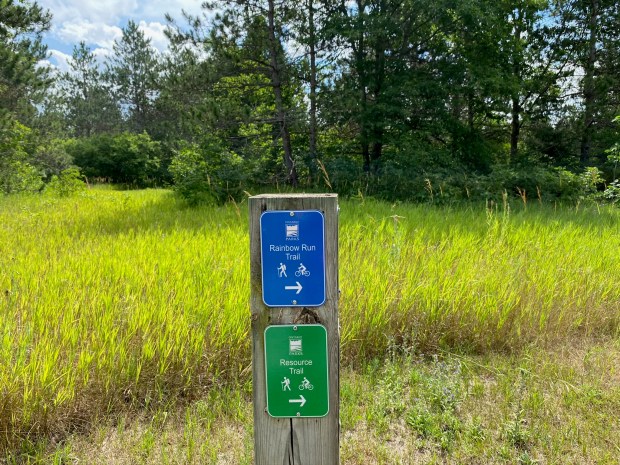
There are four smaller trails scattered around the park and one larger trail, Rainbow Run (11km loop, rated easy) that encompasses the entire trail system. We parked at the East Beach and wandered around the beach area until we found a trail marker for Rainbow Run.
The first stretch of the path was paved and followed along the Fletcher’s Mill Pond Trail (1.5km one-way, rated easy) around Earl Rowe Lake. There were a couple of interpretive signs that tell the history of Earl Rowe Lake. It was created in 1964 when a dam was built on the Boyne River. At the same time a fishway was built at the dam site to ensure that rainbow trout could continue their annual migration up the river to spawn.

From there we followed the trail to the Little Trail (0.5km one-way, rated easy), which winds through a forest toward West Beach. From there, the path leads through a large open meadow.


The path then follows the shoreline of Earl Rowe Lake and provided lots of great encounters with the wildlife: the geese.

Rainbow Run then follows along the Resource Trail (1.5km loop, rated easy). You know it’s going to be a good time when the description of the trail recommends bug repellent. The trail features a number of interpretive signs that provide interesting fun facts about the various plans and animals found in Earl Rowe Provincial Park. The trail also features large hordes of mosquitoes. The path passes through several habitats adjacent to the Boyne River, including wetland and hardwood forest.
It was a bit unclear where the Rainbow Run trail continued at this point. After wandering around for a bit, we finally found a marker. We then followed the path through an open field, passing by some of the campgrounds, before meeting up with the Lookout Trail (4km loop, rated moderate). The trail ascends up a hill to a small lookout platform overlooking the surrounding area.


From there we followed the trail down and through a red pine forest. There was a sign here that explained that the forest along this section was planted during the mid-1960s in order to provide a windbreak for the open field habitat of the park.

We finished our hike shortly after 12p.m. Initially we planned to go swimming after our hike, but the lake was closed to swimming due to high bacteria levels. Since the lake is surrounded by agricultural fields and there is minimal water flow, it is subject to run-off, which sometimes creates unsafe conditions for swimming. Instead we drove back home to Toronto. At least this way we didn’t have to worry too much about traffic as it was still early in the day.
L
My progress on the 52 Hike Challenge can be found here
We found that some of the park trails we took while travelling through Ontario were a bit indistinct, as well. This was even worse if the trails were underutilized. Wandering around can be good, but not if you get lost. Looks like you found a bit of everything on your hike. Enjoy the weekend. Allan
Some of the trails here are certainly a bit sketchy. For the Rainbow Run trail, it was weird because the path itself was well-marked, except at junctions, which seemed like a pretty key place to mark the trail. At least we were wandering around in an open field, rather than through a dense forest with aggressive mosquitoes. Either way, we still had a lovely hike. Take care.
A beautiful trail, but I’m glad you had bug repellent. And with the extreme heat, I’d be tempted to dip my toes in that lovely water.
We had planned to go swimming afterwards. What better way to end a hike!? But the lake was closed for swimming due to high bacteria levels. Usually this wouldn’t be a problem as there is also a one-acre swimming pool, but it was closed this year due to the pandemic. Bummer about the swimming, but the trail was pretty nice.
According to your standards, this seems to be a pretty easy walk, I’m glad you enjoyed it in the same way.
The trail itself was relatively easy with minimal elevation gain, which was great because it was pretty humid outside and we weren’t looking for a super strenuous hike. For the post part it was pretty well-marked, except for at a few junctions. Thanks for reading and commenting.
What a lovely park, it would be a perfect place for a family picnic with lots of yummy treats by the lake shore! Sometimes it’s great to take a nice long and mostly flat trail, minus mosquitoes, of course. Thanks for sharing and have a good weekend 😊 Aiva
Agreed, this place definitely seemed to be a good picnic spot. There were plenty of picnic tables spread out around the beach areas. It’s very family friendly. The trails are all relatively flat and the path is quite wide. Thanks for reading and hope you’re having a wonderful weekend too.
Yet another park waiting to be discovered! Thanks for spotlighting this. I like that it’s so close to Toronto. Might be something for my family to check out one day too.
Even though Earl Rowe is so close to Toronto, this was my first time visiting. It’s definitely very family friendly and the trails are all rated easy. They also offer their own park patch / sticker. The only downside is that the beaches seem to be closed on the regular due to high bacteria levels in the water. There is a large outdoor swimming pool, but it was closed this season to the pandemic.
Ahhhh! I’d love to go trail running there!
The Rainbow Run trail would certainly make for a good running route. The path is quite wide, relatively flat and there aren’t too many rocks or roots. Who doesn’t love a run with nice views along the way?! Thanks for reading and commenting.
Beautiful park! 🙂 The mossies this spring and summer were really, really bad, though. Standing still for more than a few seconds was awful. Even spraying down from head to foot would only last about 20 minutes.
I was thinking the same thing, but was questioning myself and whether it’s because I’m just noticing them a lot more since I’ve been spending more time out in their natural habitat. And I swear they are becoming immune to insect repellent. I’m glad the mosquitoes are gone for the year!!
Wonderful hike.
It certainly was a nice way to spend our morning. The hike wasn’t particularly strenuous, which was great as it was very humid outside. The path was for the most part very well-marked (except at a few junctions) and there were lots of options to scale up or down depending on how long you wanted to go hiking. Thanks for reading and commenting.
It looks like a beautiful and not too difficult hike. I’ll have to add it to my list to get to one day.
It was a pretty pleasant hike. The trails are all connected so you can scale up or down depending on how long you want to hike for. Thanks for reading and commenting.
I told my husband that your posts make me want to visit Canada again. Every photo is so pretty.
Thanks for your kind words. The grass is always greener on the other side. I would love to visit Yosemite and just California in general. Looks like there are some great trails there and it’s such an entirely different landscape compared to Ontario!
California is a beautiful state (when it’s not filled with wildfire smoke). 🙂
I’ve heard that 2020 has been the most severe season for wildfires in California. While fires can be good for the forest ecosystem, they can also be hugely destructive. And that smoke can’t be good. Stay safe.
This one looks a lot more flat than the other hikes that I have seen on your blog? So there isn’t amazing mountain scenery all over Canada? 🙂
It does, of course, still look like a lovely hike. 🙂
Ha, I wish we had more mountains in Canada, especially Ontario. This trail is located in central Ontario, which isn’t as hilly as when we were in Northern Ontario around Lake Superior this summer. This wasn’t one of our favourite hikes this year, but it gave us something to do and it’s always fun exploring a new provincial park.
Looks like a great place to hike!
Many of the trails are interconnected, giving you plenty of options for a shorter or longer route depending on how much time you want to spend hiking. The trails are also well signed and relatively easy to navigate. Thanks for reading and leaving a comment.
Sounds great. I’ve been on trails here where they are so poorly marked you could get lost. Nice post !
For sure. I am directionally challenged, so I appreciate a well marked trail that is easy to navigate. I have my fair share of stories of getting lost on the trail!
It’s a great trail. I enjoyed your post. This past August 6th I participated in a running race on the Rainbow Run Trail. There was four distances and I was running the longest one of 96k (8 loops of 12). In reading your post about being unclear about the markings, fortunately we had orange flags.
It was such an extremely blistering hot day & by 60k I was experiencing heat related symptoms. Medics recommended I call it a day.
Unfortunately I didn’t get any photos and I was wondering if I could have your permission to use two of your photos for my race recap for my blog. The 1st photo of the Rainbow Run Trail signpost and the one of the pedestrian bridge over the river. I will credit you with the photos and link this blog post if you like.
Thank you, here is the race website.
https://raceroster.com/events/2022/56372/rainbow-trail-run-2022
Thanks for your kind words. It’s neat that there was a running race along the Rainbow Run Trail. I guess the trail was aptly named to have the word “run” in it. Congrats on participating in the longest race. Sorry to hear that you were impacted by the heat and weren’t able to finish. 60km is still a very impressive amount of distance to cover!!
You are more than welcome to use some of my pictures for your blog and many thanks for offering to credit them and link to my post. Looking forward to reading about your race recap.
Thanks! Linda
This is very kind Linda. Thank you so much for your permission for the use of your photos. And thank you for your encouragement and generous comment. 😀🙏🏃♂️
Of course, anytime. Always happy to share my love (and pictures) of Ontario’s provincial parks 🙂