
Length of stay: 4 days
Visited: August 2016
Highlights:
- Grinnell Glacier
- The High Line
- Hidden Lake Overlook
- Seeing a grizzly bear
Glacier National Park is located in northwestern Montana along the US-Canada border just south of Waterton Lakes National Park. Together these two parks formed the first ever International Peace Park to better preserve and protect the shared ecosystem along the Continental Divide. Spanning across a million acres, Glacier National Park is home to 25 active glaciers (although scientists estimate they will all disappear by 2030), 71 species of mammals (including the grizzly bear!), and 151 trails (totaling 1,200km). The Going-to-the-Sun Road, the park’s only road that cuts through the park, offers exhilarating views as you’re winding around, through, and over the mountainous terrain.
The below map provides an overview of our four day adventure at Glacier National Park.
Day 1: Avalanche Lake
We flew into Calgary the day before to embark on a 12-day road trip across a number of national parks scattered in the area. We spent the early morning in Waterton Lakes National Park just north of the US border. After getting in a short hike coupled with a few detours to hit up some of the main attractions we headed south towards Glacier National Park. The closest border crossing (while seasonal) is at Chief Mountain – only about a 30km drive from Waterton. We planned to stay here for the next four days.
There is just one road that cuts through the park: Going-to-the-Sun Road. We entered at the eastern side of the park at St. Mary’s and didn’t stop for any of the viewpoints or lookouts along the way because we were on a mission to secure a campsite at Avalanche Campgrounds, which are all administered on a first-come first-served basis. We rolled in just before noon and set up our tent at a particularly secluded site and ate some lunch.
From the campground we walked to the Trail of the Cedars. It’s a short (wheel-chair accessible) loop that connects with the Avalanche Lake Trail (not wheel-chair accessible). Near the beginning of the Avalanche Lake trail (7.2km roundtrip) there are incredible views into a gorge that has been carved out over time by Avalanche Lake.

While we were hiking along the trail some random guy pointed out signs of destruction when an avalanche rumbled through this area a few years prior. Evidence of its destruction were clearly visible from the trail as there was a large section of trees ripped from out of the ground and their remnants strewn all over the place.
The trail itself is groomed and well trodden. There are some particularly hilly sections, but for the most part it was pretty easy hiking. The trail ends down at the beach of Avalanche Lake where hikers can rest along the rocks and admire the turquoise blue waters surrounded by mountains.

We hiked back towards the Trail of the Cedars and finished the rest of the loop. From there it was just another couple minutes of walking back to our campsite. We made an early dinner and relaxed for a bit before heading back out.
We drove towards the western entrance of the park to the Apgar Visitor Center to enroll in their Junior Ranger Program (we have to collect all the badges!). And because 2016 marks the National Park Service’s 100th birthday we got a special centennial junior ranger activity book to fill out as well!
From here we drove down to Fish Creek campground to the trailhead of Rocky Point (3.1 km roundtrip). The trail meanders through a section of the forest that was ravaged by the 2003 fire and allows hikers the opportunity to see the important role forest fires can have on an ecosystem. Over a decade later signs of new life and habitation have sprouted up.

It was a short drive to return to the Apgar Village for their evening ranger program on the night sky. Ranger Emily read stories from native american folklore on coyotes, owls, and bats.
Day 2: Hidden Lake Overlook & the HighLine Loop
We woke up earlier than usual to guarantee a parking spot at Logan Pass. We read ahead of time that the parking lot is typically full by 8:30a.m. We were among some of the first hikers fresh on the scene. We first hiked to the Hidden Lake Overlook (4.3km roundtrip). The path starts behind the Logan Pass Visitor Center along a paved path. The path eventually tapers off to a series of boardwalks through the alpine meadows until you reach a viewing platform that overlooks the Hidden Lake.

Along our hike to the Hidden Lake we saw a bunch of Columbia ground squirrels – a rodent that resides in mountainous regions and alpine meadows throughout certain parts of North America. We also saw three mountain goats near the viewing platform at the top. One of them went onto the boardwalk and was licking the top of the railing. The other two were just snacking on some of the nearby vegetation a little ways off the boardwalk.


The path continues onward for another couple of kilometers to the base of the Hidden Lake. We ended up hiking a bit further because there were three more mountain goats located nearby. We sat on a rock and watched them until they eventually passed us. We opted not to continue down to the base of the lake as we were planning to hike the Highline Loop afterwards. Plus the views are better from up top anyway.

The benefit of being such an early riser is that we only encountered two other small groups of hikers on the ascent to the Hidden Lake Overlook. It wasn’t until our descent down where we realized that they weren’t kidding when they say that this is a very popular trail. By the time we reached the parking lot it was completely full and cars were circling nearby like vultures waiting for a spot to clear up.
We headed back to the car to eat a snack, drink some water, and prepare our pack before heading out to hike the Highline Loop. The trail actually consists of two intersecting trails – The Highline and The Loop. It is recommended to start this hike at the entrance across the road from the Logan Pass Visitor Center and end at the car park at The Loop. You can then take the park’s (free) hop-on-hop-off shuttle service back to your car.
The first part of the trail is The Highline (12.2km one way). It starts at Logan Pass and ends at the Granite Park Chalet. The trail, as its name suggests, is high in the mountains and follows along the Continental Divide and the Garden Wall – a lush alpine wall covered with wildflowers and plant life. The trail is relatively flat and quite scenic. But hiking close to the ledge of a mountain is definitely not for the faint of heart. There is a particularly steep section near the start of the trail along a ledge where a cable is attached to the wall for additional guidance. Since the path is quite narrow, it can be challenging to pass people. And there aren’t many places to take a break either. But the views from up here are incredible.


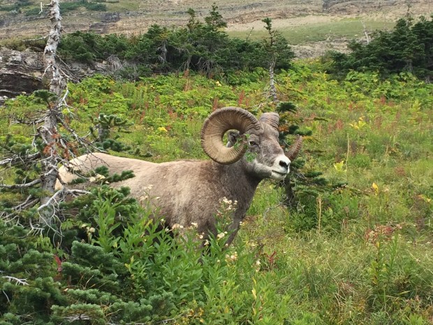
Along our hike we spotted some wildlife on the trail – a bighorn sheep and a hoary marmot.


We also stumbled upon an older lady who fell and broke her arm along a particularly dicey section on the trail littered with loose rocks and bits of shale. A park ranger was busy casting her arm while a few other hikers were kindly offering her snacks and water. We were reminded of the stark consequences of hiking so precariously close to the edge of a cliff.
A few metres before the Granite Park Chalet is an option to hike an additional 1km for an overlook of Salamander Glacier and Grinnell Glacier. At this point we were getting tired. And running out of water. And that trail looked super steep. We decided to just bypass it since we planned to hike up to Grinnell Glacier on another day. We rested at the Granite Chalet before continuing onward. The chalet has next to no amenities but does sell a variety of snacks and beverages. We contemplated purchasing water here (as there was no place to refill our water bottles). But $5.50 USD for 1L of water seemed a bit steep. And besides, we only had about 6km remaining of our hike.

The second part of the trail is called The Loop (6.1km one way). And it sucks. Turns out this trail is pretty much entirely downhill. It was the worst. And since a forest fire had ravaged the area, there was no protection from that unrelenting sun. And it was hot. In retrospect we should have bought the (world’s most expensive) water back at the Chalet.

We nearly wept with joy after finishing the hike. And thankfully we didn’t have to wait long for a shuttle to arrive. We started the Highline Loop at 10:15a.m and finished just before 3:30p.m. As soon as we returned to Logan Pass we hobbled off the bus to rehydrate by the water fountain. We also added some electrolyte tables to our water – something we foolishly left behind in the car.
We drove back to our campsite and took a nap after all that hiking. We woke up around 6:00p.m, made some dinner and played some cards. A couple of hours later it started to briefly (very briefly) sprinkle. We also heard some booms of thunder. But it was short-lived. We went to bed shortly after though. We were exhausted. Lessons learned for next time: bring more water.
Day 3: Waterfalls
We slept in this morning until around 7:30a.m. We boiled some water for tea and oatmeal, tore down our tent and packed up. We drove east along the Going-to-the-Sun road towards the Rising Sun Campgrounds – also administered on a first-come first-served basis. We found a particularly secluded site, set up our tent and threw our sleeping pads and sleeping bags inside. We then walked over to the front of the campground to the bus stop. We decided to take the shuttle to St. Mary’s Falls as we read that parking at the trailhead is rather limited. We waited for about 15 minutes for the bus to pick us up, but it was already nearly full. We spent a few minutes sorting out which groups of hikers were waiting the longest. We were the last two people to scamper aboard.
We set out to hike to Virginia Falls which passes Mary’s Falls along the way (5.8km round trip). There are actually two trailheads to St. Mary’s Falls – one that is accessible only from the shuttle stop and the other from the car park. We’re not sure which path is longer, but the difference is pretty marginal.
The path is relatively flat (there is very little elevation gain) and leisurely winds through a burnt section of the forest until you reach St. Mary’s Falls.


Continuing onward the landscape transforms dramatically from burnt trees to a particularly lush and dense forest. The shade from the sun was quite welcome. The path follows beside the river and provides further opportunities to see some other minor waterfalls before coming to the end at Virginia Falls.

We turned around and hiked back to the bus stop for the shuttle. We only had to wait about 5 minutes or so for the bus to arrive. We returned to the Rising Sun Campgrounds to shower. Shower facilities within the park are rather limited – there are ones available at St. Mary’s Campgrounds and at Fish Creek, but only to registered campers. The only other option is at the General Store at the Rising Sun Campgrounds, which we were conveniently staying. We gladly forked over $5.11 for two shower tokens where each token is good for 8 minutes of hot water. This marked the first shower of our trip. And it was long overdue. It was wonderful.
After getting all cleaned up we headed back to our campsite to make some lunch. We then hit the road again and drove out to the Sunrift Gorge – located a mere 200ft from the parking lot. We first crossed the road and followed a path that consisted of climbing a few steps to a nice viewing area of the narrow gorge carved out by glacial runoff.

We returned to the parking lot and followed the other path that continues to follow the gorge towards Baring Falls (1.3km roundtrip).

Once we returned to our car we drove towards the St. Mary’s Visitor Center to scope it out and, more importantly, hand in my completed junior ranger booklet to receive my badge. While we were there we checked out the 15 minute film about Glacier National Park before heading back to our campsite for dinner.
Afterwards we drove to the St. Mary’s Campground for the evening ranger program with Elizabeth to learn more about the geology of the park. “Silt, Tilt, Slide, and Glide”. It was probably one of our favourite ranger programs ever – not as good as the one on Bear Awareness at Yellowstone, but probably a close second.
Day 4: Grinnell Glacier
Our last day at Glacier National Park. We decided to spend it over in Many Glacier which is reputed to be prime grizzly bear territory. So much so that the Iceberg Lake trail remained closed over the past couple of weeks due to bears frequenting the area. Instead we decided to hike up to Grinnell Glacier. Since this is one of the most popular trails in the park, it is heavily trafficked by hikers. So we weren’t too concerned about encountering a bear.
There are two options to hike to Grinnell Glacier. The shorter option is to take two shuttle boats, one across Swiftcurrent Lake and the other across Lake Josephine, to shave off about 5.5km of the entire hike. All for a fee of course ($13 for a one-way trip and $26 for a roundtrip). The second option is to just hike around both lakes.
Given that it was a pleasant day outside and the terrain around the two lakes has minimal elevation gain, we opted for the latter.
The first portion of the trail meanders through the forest. The trail then opens up into the valley and hugs the shoreline of the two glacier fed turquoise lakes. After passing by Lake Josephine, there is a junction in the trail – you can hike down to Grinnell Lake up to Grinnell Glacier. For those going to the glacier, this is where the ascent begins.

The elevation gain for the first stretch is quite gradual. The sweeping vistas into the valley only get better the further you proceed. The final stretch of the trail was the steepest, but the most rewarding as the view from up top is the best. Sure, the glacier isn’t nearly as impressive as in former years (it has shrunk to barely anything), but the iceberg lagoon was stunning.


On our return journey, we encountered this massive bighorn sheep who was blocking the path. A group of us slowly followed him (from a safe distance of course) for at least 20 minutes or so until we could find a spot to safely pass him.
When we returned to the car, we ate some snacks and relaxed for a bit. This provided an opportunity to fill out our special centennial junior ranger activity book.
On the way back to the campsite we stopped off at the St. Mary’s visitor centre but unfortunately were a few minutes shy of closing time. As we were nearing our campground there were a cluster of cars and people by the side of the road. Some people were even standing on the roof of the vehicle with a camera or cell phone held out. We pulled over as soon as we found space and decided to see what all the commotion was about. Turns out there was a grizzly bear in the meadow near some berry bushes. The rangers were quick to the scene and ordered everyone to disperse.
And if that isn’t enough bear activity when we returned to our campsite there was a black bear in the berry bushes in the campsite across from us! Once again, the rangers were there in no time to remind everyone to keep their campsite free of food, dishes, pots, and anything and everything that might have come into contact with food.
We waited a bit to make dinner (we didn’t want to have to share with the bear). Afterward eating, we walked to the amphitheatre at our campground to attend the evening ranger program on the deer and wolf cycle.
Day 5: Grizzly Bear Sighting
We woke up at 6:30a.m to take down our tent, pack away our gear and hit the road. But we’re including an extra “day” for today because …(wait for it) …we saw a grizzly bear near the road! It was probably the same bear we kinda saw yesterday as it was in the same location. But this time the bear was closer to the road. And this time we stayed inside our car. This was our ideal grizzler encounter.

This marked a fantastic end to our visit to Glacier National Park. From here it’s about 400km to Canmore, Alberta – our next stop on our 12 day road trip out west.
L & K
What a beautiful park, and great write up of the experience. Hoping to do an ultra there sometime in the next few years. Montana is definitely calling to me.
It really is. It’s probably one of my favourites. All the best with your ultra marathon! Sounds intense. Especially given the mountainous terrain in Montana!
When we visited Glacier a year ago, smoke from forest fires dulled the views. Within days of our visit, parts of the park were closed. New fires have arisen this year:
http://www.krtv.com/story/38912342/howe-ridge-fire-in-glacier-national-park-saturday-update
Even though forest fires are good for forest regeneration and are a natural part of the forest ecosystem, their effects are nevertheless devastating and frightening. And obviously they are not ideal for camping, hiking and soaking in the views. I guess this means that you’ll just have to come back one day. We were lucky we had such fabulous weather when we visited. A week after we left parts of the Going-to-the-Sun Road were closed due to a massive snow storm.
Closed for fire, closed for snow. Can’t say there’s no variety.
While I was sorry not to get any landscape pictures with the clarity of yours, the smoke made for some effects I couldn’t otherwise have gotten and that were worth it in their own right, like
https://portraitsofwildflowers.wordpress.com/2017/10/04/eerie/
Indeed. Glacier looks like a smoky apocalypse in your eerily hazy picture. Looks terrifying.
Picturesque, like pictures from postcards and calendars. Montana is blessed with stunning nature. Hope to see it one day. Thank you. Great adventure.
The mountains in Glacier National are very majestic and they made for some incredibly scenic hiking. It was also an added bonus to spot some wildlife on the trail. Hopefully you’re able to see it in person someday. Take care. Linda
I hope so too. Thanks. Happy weekend.
Thanks! We’re currently in Venice, Italy at the moment. Hope you had a wonderful weekend as well. Cheers. Linda